According to our motto, to simply set out, it only functions conditionally.
The entry conditions of the countries require a approximately planning of the itinerary and the determination of a time grid. As well the climatical and political general conditions should be considered for some routes.
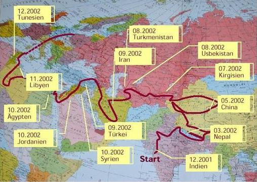
As we imagined our itinary at least in the beginning, you can learn from the following map.
During our journey we transmitted the GPS-coordinates per Short Message and described them in a map.
The map can be moved with the left mouse button. If the right mouse button is pressed and the mouse is moved up and down, the map area can be zoomed in.
The map is not complete and only covers the environment range of the travel. The colour of the map corresponds with the high over NN, not with the vegetation.
Therefore it happens that a region has another colour as you would expect.
Technical realisation : bit~side GmbH